Friday, February 14, 2014

Augusta Springs Wetlands Trail

Wanting to get in the woods this past weekend and with no hikes planned, I packed up my senior basset Waldo and we headed out to find a trail somewhere.  It was a cold blustery day and there were snow flurries flying but I put his warmest jacket on him and packed warm clothes for myself and we headed out.  I thought about driving up to Skyline Drive or Blue Ridge Parkway but it was already afternoon and couldn't think of a trail that was short and close so decided to head to Staunton and try out some of the trails at Montgomery Hall Park. 

On my way to Staunton, I remembered a trail I had done last winter just west of Staunton past Buffalo Gap and remembered that it would be perfect for a day like today so west we went and made the short drive to the Augusta Springs Wetlands Trail, part of George Washington National Forest.  This trail is on the grounds of what once was a resort where people came to partake of the springs.  There are still remnants of the once great resort remaining as well as the foundation of an old bottling plant (August White Lithia Springs).

The trail is made up of two loops, one that is accessible and one that takes you up over the ridge and around through the woods and various streams.

The wetlands trail has several interactive stops along the way and discusses the wildlife that can be found there in the wetlands.  It also includes many boardwalks so that you don't have to walk in the wetlands.


This accessible trail meets up with the adjacent hiking trail, called Uplands Trail, and you can veer off the flat wetlands and start climbing up over the ridge.  This part of the trail, though, can be particularly muddy on wet days.  As you climb through the woods, the trail is well maintained and marked and Waldo and I enjoyed stretching our legs.


Coming down the backside of the ridge, if going in a counterclockwise direction, the trail is a bit steep but the footing is good.  Here is a picture looking back up the hill after coming down.


As the trail winds back down among the many streams we once again find remnants of the bygone era of the resort and its working.  There are some areas along the way with lots of glass jars and metal that could have perhaps been the makings of bottled water, or maybe moonshine made with the fresh, spring water.


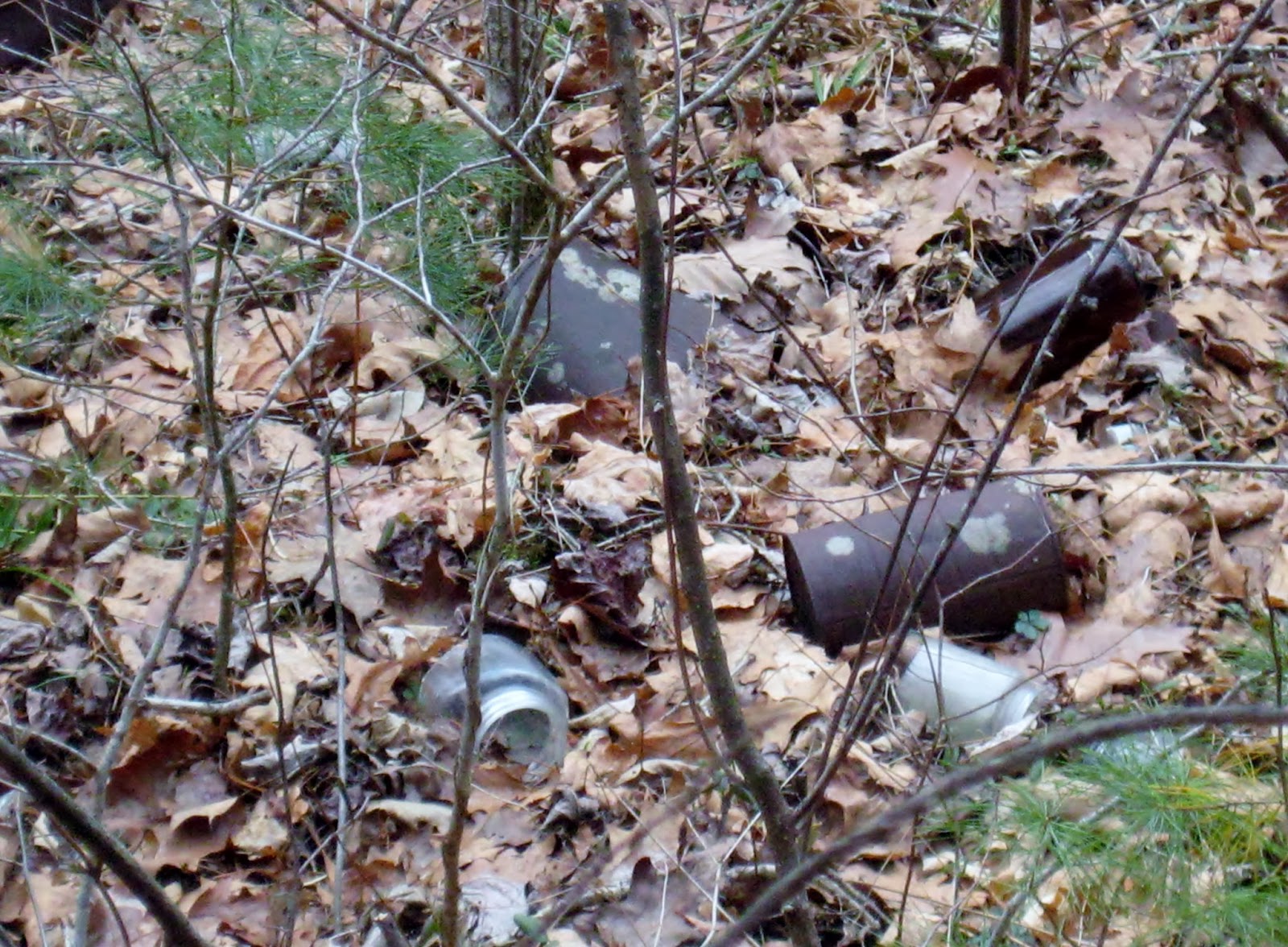
And maybe their get-a-way car, too?
 
 
The trail then comes back and joins the wetlands trail where you can walk through the heart of the old resort area with the reminders of its former glory like the fountain and the flumes to bring the spring water to the guests.


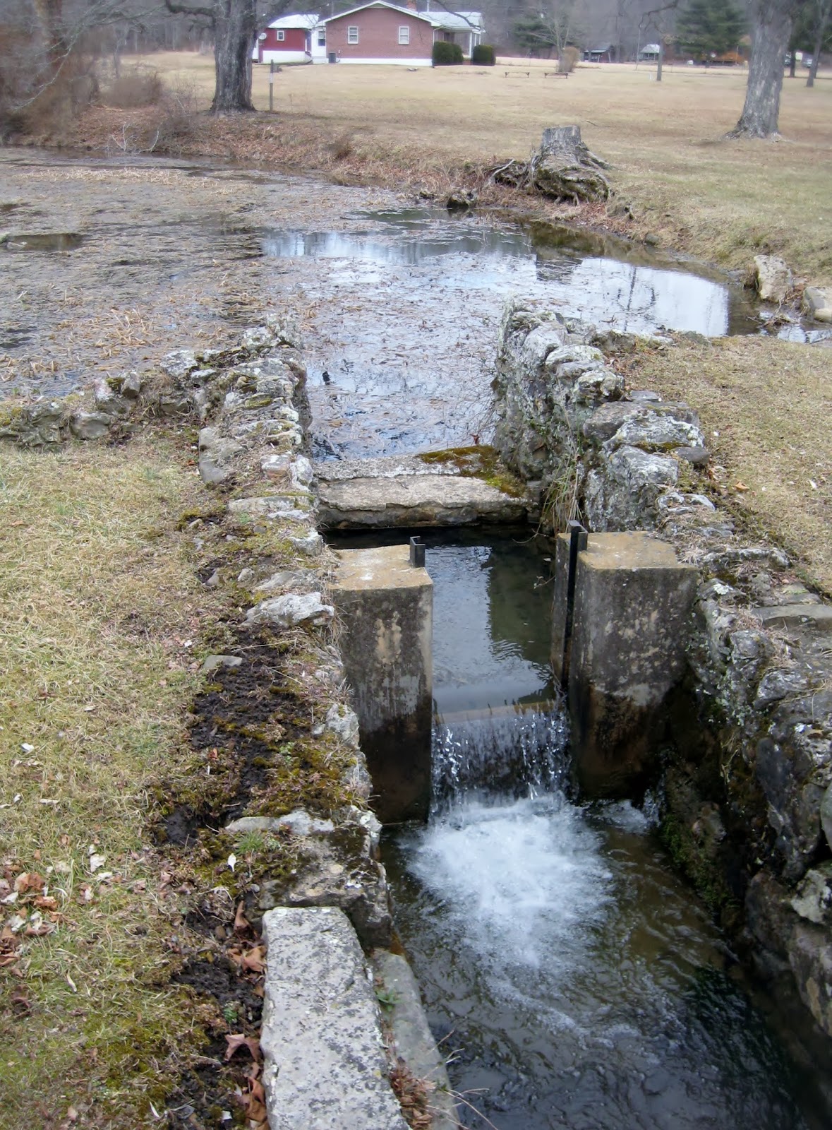
The beautiful spring is still there with the ruins of the springhouse, too.


Waldo and I had a great afternoon and I recommend this little trail for anyone looking for a nice way to stretch their legs, enjoy the woods, and visit a historic site.  The wetlands trail is about .7 miles long and the uplands loop is another 1.3 miles.  This is a trail that anyone, including a senior basset hound, can enjoy so take the whole family!


For more information, visit here.


Saturday, February 8, 2014

Spy Rock and Crabtree Falls

The girls were out and about again and decided to knock a couple more hikes off of the top 20 list.  We started early in the morning and when we arrived at Spy Rock, we had the parking lot to ourselves.  I love it when we arrive to an empty parking lot because that always means fewer people on the trail.

Spy Rock made it to the 2nd most popular trail on the Virginia Hiking Guides top 20.  I have always seen plenty of hikers and backpackers on this trail, so that doesn't surprise me.  Once you get just below the great dome of rock known as Spy Rock, there are wonderful spots for camping out on a lovely open mossy ridge so most weekends you will find some folks camped out here.

The beginning of the climb to Spy Rock is basically up a private road with several private camps and cabins.  This part of the trail is fairly boring and this morning we found a lot of ice and snow on the road.


Interestingly, once we gained some elevation the snow and ice cleared out and we just had a muddy trail joining up with the AT.  We continued along the AT until reaching the nice clearing with the campsites.
 
 
This spot is particularly lovely in the spring when all of the mountain laurel are blooming as you walk through large areas full of the mountain laurel.  This is the point that the hike becomes really fun as you have to climb the rock looming ahead.  The dome is made up of a large rock which has a rough surface and makes it pretty easy to climb, but there is some hand over hand climbing involved as seen in the next picture.

 
The payoff is worth it, though, because once up on the dome, you have beautiful panoramic vistas of range after range after range of mountains.


On top of the rock are lovely pools of water which are full of tadpoles in the summer and small shells year-round.  There are also some rather large crevices for exploring, if you are so inclined.


This is an up and back hike so after enjoying some lunch up on the rock, we returned the way we came.  This is not a long hike, just over three miles, but does gain some decent elevation.  If you would like more information about this hike, you can visit this site.
 
 
Only a few miles away, is another hike on the top 20 list, Crabtree Falls.  Crabtree Falls is listed as number 6 on the top 20 list.  Crabtree is very popular year-round and you almost never have this trail to yourself but the waterfalls never disappoint.
 
As with all of our hikes this winter, the water was flowing strong but Crabtree had far more ice than any of the other falls.


Unfortunately, we were only able to get up about .5 mile before encountering large icefields blocking the path, so for safety's sake we turned around and will have to complete this one another day, although we had all done this hike before.  Here are some more pictures of the beautiful, frozen waterfalls found on this trail.


For more information about Crabtree Falls, see here.