Thursday, May 15, 2014

White Oak Canyon and Cedar Run

Last year, I did this hike starting at the bottom and hiking up White Oak Canyon and then back down Cedar Run.  This year, we started at the top on the Skyline Drive and hiked down Cedar Run, across the link trail and then up White Oak Canyon. 

The forecast was for a chance of storms later in the day and we started early hoping to finish before the storms hit.  Cedar Run is a very rocky and steep trail following Cedar Run as it tumbles down gorge after gorge.  The path is well marked but there was plenty of evidence of a brutal winter with many downed trees.  There were lots of wildflowers blooming along the trail.


About half-way down Cedar Run, we startled a young black bear and he sat just uphill from us watching as we passed by.  A little later on, we saw a small black snake and chipmunk, as well.


At the lower end of the Cedar Run Trail is a natural waterslide that is usually busy during the warmer summer months.  One of the times, I will visit here during the summer with a swim suit so that I can try it out.

 
We descended a little lower and found a terrific spot for lunch.  So far, so good no rain.
 
We trekked across the link trail to the White Oak Canyon trail crossing the river before beginning our steep ascent up White Oak Canyon.
 
 
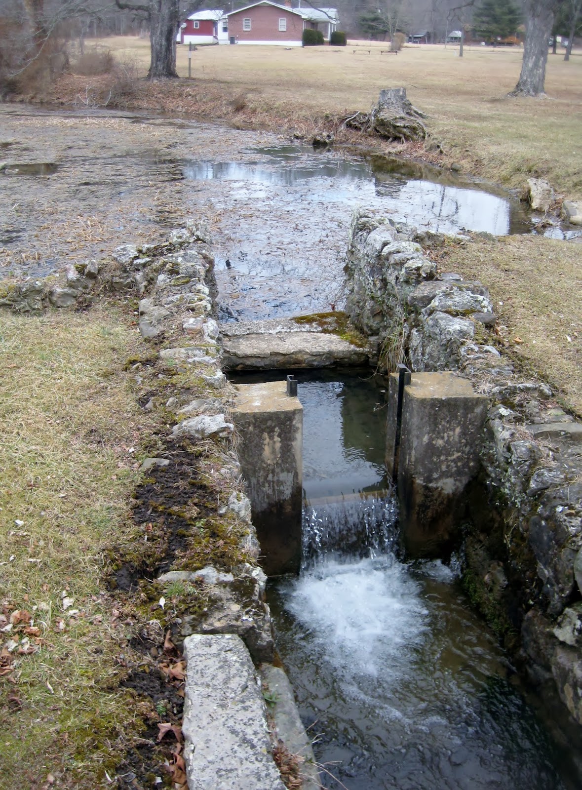
Just like the Cedar Run trail, White Oak Canyon trail stays right along the river with beautiful cascades and pools the entire time.  About half-way up, you come to the impressive lower falls and as you continue to ascend, you reach the upper falls.  The Lower Falls are broad and with full volume while the Upper Falls are taller, but a smaller stream.  Both are beautiful.
 
Lower Falls
 
Upper Falls
 
 
Shortly before we reached the Upper Falls, the rain had finally arrived and by the time we actually reached Upper Falls, it was falling steadily.  Because of the rain, and other things, we missed our intersection to the fire road that would have completed our 8.8 mile hike and continued up the White Oak Canyon Trail for a few more miles.  While this made the hike much longer than we intended, 10.5 miles instead, it also created a problem in that we came out on the Skyline Drive three miles north of our cars.  Hmmmm.  We met up with a kind soul who was willing to drive a couple of us wet and muddy hikers to our cars and then they could drive back and pick the rest of us.  It made for an interesting end to our adventure but we got to see some new and beautiful scenery along the way.


This completed number 7 on the list of top 20 hikes in Virginia.  If you would like to learn more about this hike, you can visit here.


Thursday, April 10, 2014

McAfee Knob

The second day of the Valley Adventure Girls epic weekend involved hiking to the iconic overlook of McAfee Knob.  This is one of the most photographed spots on the Appalachian Trail and rightfully deserved. 

Since we had hike the 10 miles of Mount Rogers the day prior, we were moving pretty slowly as we set out this morning.  This is a very popular trail and we saw lots of college-aged groups on this trail.  Since we knew we were moving at a slower pace, we always stopped and let them pass.  One of the interesting things about this hike is that it is the exact opposite of the hike we completed the day before.  Mount Rogers is scenic the entire way until you reach the summit which is then just a large rock in a thick stand of trees.  McAfee Knob is an average walk in the woods until you reach the overlook at which point you are wowed by the view.

Starting out from the parking area off Rte 311, we ascended, descended, and then ascended again.  We passed lots of rhododendron and I expect that this walk in the woods is probably a lot prettier about a month later than we did it.  We did spot some signs of spring in the form of early flowers.


This part of the AT has several footbridges built as part of an Eagle Scout project which makes traversing some large rocks a little easier along the trail.

Just a little further down the trail, you come upon one of two shelters and privies built for hikers of the AT.  They are both nicely situated.

The trail is approximately 3.8 miles until you reach the sign for the overlook.

From this point on, you will ooh and aah at the views unfolding before you.  You first come upon "the ledge" and wait your turn to have your picture taken there.

As you continue on around the rocky ledge, many views and valleys are there to behold including a nice view of the Roanoke Airport.


We enjoyed a nice lunch on the rocks and took lots of pictures before slowly heading back to our car. 

This trail is rated number 7 on the Top 20 list.  While the trail itself is not spectacular, the views at the summit certainly are and I think this hike should be ranked higher on the list.  For more information about this hike, you can visit here.


Wednesday, April 9, 2014

Mount Rogers/Grayson Highlands

WOW, WOW, and WOW.

Several weeks in the planning was a weekend away which would allow us adventure girls to travel to the far western corner of the state to hike Mount Rogers, which was number one on the list of top 20 hikes.  We were all anticipating this hike because every review and every picture viewed prior to making this trek was wonderful.  Needless to say, this one will be no different.  Mount Rogers and Grayson Highlands is a feast for the senses and a must-see for every hiker in Virginia.

This hike boasts everything but the kitchen sink.  There are wonderful alpine meadows, there are fabulous rock scrambles, there are enchanted emerald forests, and there are even wild ponies.  We were constantly in awe of what we saw; we were amazed at what we felt; and even enjoyed some of the smells.

We started at the Massie Gap parking lot within Grayson Highlands State Park.  From there, we crossed a field and ventured through a stile on to the Rhododendron Trail.  We were greeted from the start by signs warning us of extreme weather changes and were wondering if we had on enough clothes.  (Some would say no and wished they had hats and gloves).


In less than a mile, we came upon our first group of wild ponies.  While not necessarily friendly fellows, they are far from wild.  There are many signs that ask you not to feed them and signs warning that they do kick and bite.


After spending a little time with the ponies, we continued on through the meadows that approach the boundary of the State Park and join the Appalachian Trail.  We registered our visit on the trail and start up to meet the many rocky peaks ahead of us.  Traversing the alpine meadows with the craggy peaks in this area brings to mind the landscape from the wilds of the north of England and the scene from Pride and Prejudice when Elizabeth was visiting Derbyshire.  I half expected to see Miss Bennett pop up over one of the rocky ridges.

At this point, we detoured off of the Appalachian Trail to head up and over the Wilburn Ridge Trail which allowed us to enjoy two, long rock scrambles.  The view from the top was incredible.


We continued on to the yet higher peak also requiring some rock scrambling.  As we approached this peak, we were struck by what looked like fairy-dust sparkling on the vegetation.  Upon closer inspection, it became apparent that what we were seeing was ice clinging to the north-facing vegetation.  Thick, white ice giving everything an enchanted appearance.


We continued on entering a thick stand of evergreens so thick and lush that the smell immediately brought back memories of Christmases past.  There is nothing better than the fresh, clean smell of alpine air and Christmas trees.

From here we joined back up with the Appalachian trail as we neared the shelter used by AT thru-hikers.  Here we found another pony who apparently is quite famous for hanging at the shelter, hoping folks would share their meal.
He was obviously very used to hanging around people and would allow you to pet him.  He was still hanging out here when we came down on the return.


From here, we continued the short way until we reached the spur trail that took you to the summit of Mount Rogers, the highest peak in Virginia at 5728 feet in elevation.  The ironic thing about this hike is that the views are not from the top, since it is a treed summit, but almost the entire climb.  To reach the summit, you enter a dark forest thick with green moss giving it the appearance of an Emerald Forest.  The ice was still think on the tops of the trees, but the melting produced glistening drops down on the soft moss covering the forest floor and vegetation.

We finally reached the summit where we sat on a large rock next to the geological survey marker and enjoyed a well-deserved snack.

X marks the spot


 More fabulous views on the way down.  We could see ridge after ridge, after ridge.

More ponies on the hillsides.


We finally found our way back to our car exhausted but enthralled with the natural beauty we beheld.  We agreed in unison that this was now our very favorite hike and hope to make an annual trek to Mount Rogers.  We decided to do it about a month later next year so that we could enjoy the blooms of the plentiful rhododendron.


Mount Rogers rightfully deserves the title of number one in the list of top 20.  For more information about this hike, visit here .


We capped off the weekend with a visit to another popular hike the next day, McAfee Knob, which will be our next post.

Friday, February 14, 2014

Augusta Springs Wetlands Trail

Wanting to get in the woods this past weekend and with no hikes planned, I packed up my senior basset Waldo and we headed out to find a trail somewhere.  It was a cold blustery day and there were snow flurries flying but I put his warmest jacket on him and packed warm clothes for myself and we headed out.  I thought about driving up to Skyline Drive or Blue Ridge Parkway but it was already afternoon and couldn't think of a trail that was short and close so decided to head to Staunton and try out some of the trails at Montgomery Hall Park. 

On my way to Staunton, I remembered a trail I had done last winter just west of Staunton past Buffalo Gap and remembered that it would be perfect for a day like today so west we went and made the short drive to the Augusta Springs Wetlands Trail, part of George Washington National Forest.  This trail is on the grounds of what once was a resort where people came to partake of the springs.  There are still remnants of the once great resort remaining as well as the foundation of an old bottling plant (August White Lithia Springs).

The trail is made up of two loops, one that is accessible and one that takes you up over the ridge and around through the woods and various streams.

The wetlands trail has several interactive stops along the way and discusses the wildlife that can be found there in the wetlands.  It also includes many boardwalks so that you don't have to walk in the wetlands.


This accessible trail meets up with the adjacent hiking trail, called Uplands Trail, and you can veer off the flat wetlands and start climbing up over the ridge.  This part of the trail, though, can be particularly muddy on wet days.  As you climb through the woods, the trail is well maintained and marked and Waldo and I enjoyed stretching our legs.


Coming down the backside of the ridge, if going in a counterclockwise direction, the trail is a bit steep but the footing is good.  Here is a picture looking back up the hill after coming down.


As the trail winds back down among the many streams we once again find remnants of the bygone era of the resort and its working.  There are some areas along the way with lots of glass jars and metal that could have perhaps been the makings of bottled water, or maybe moonshine made with the fresh, spring water.


And maybe their get-a-way car, too?
 
 
The trail then comes back and joins the wetlands trail where you can walk through the heart of the old resort area with the reminders of its former glory like the fountain and the flumes to bring the spring water to the guests.


The beautiful spring is still there with the ruins of the springhouse, too.


Waldo and I had a great afternoon and I recommend this little trail for anyone looking for a nice way to stretch their legs, enjoy the woods, and visit a historic site.  The wetlands trail is about .7 miles long and the uplands loop is another 1.3 miles.  This is a trail that anyone, including a senior basset hound, can enjoy so take the whole family!


For more information, visit here.


Saturday, February 8, 2014

Spy Rock and Crabtree Falls

The girls were out and about again and decided to knock a couple more hikes off of the top 20 list.  We started early in the morning and when we arrived at Spy Rock, we had the parking lot to ourselves.  I love it when we arrive to an empty parking lot because that always means fewer people on the trail.

Spy Rock made it to the 2nd most popular trail on the Virginia Hiking Guides top 20.  I have always seen plenty of hikers and backpackers on this trail, so that doesn't surprise me.  Once you get just below the great dome of rock known as Spy Rock, there are wonderful spots for camping out on a lovely open mossy ridge so most weekends you will find some folks camped out here.

The beginning of the climb to Spy Rock is basically up a private road with several private camps and cabins.  This part of the trail is fairly boring and this morning we found a lot of ice and snow on the road.


Interestingly, once we gained some elevation the snow and ice cleared out and we just had a muddy trail joining up with the AT.  We continued along the AT until reaching the nice clearing with the campsites.
 
 
This spot is particularly lovely in the spring when all of the mountain laurel are blooming as you walk through large areas full of the mountain laurel.  This is the point that the hike becomes really fun as you have to climb the rock looming ahead.  The dome is made up of a large rock which has a rough surface and makes it pretty easy to climb, but there is some hand over hand climbing involved as seen in the next picture.

 
The payoff is worth it, though, because once up on the dome, you have beautiful panoramic vistas of range after range after range of mountains.


On top of the rock are lovely pools of water which are full of tadpoles in the summer and small shells year-round.  There are also some rather large crevices for exploring, if you are so inclined.


This is an up and back hike so after enjoying some lunch up on the rock, we returned the way we came.  This is not a long hike, just over three miles, but does gain some decent elevation.  If you would like more information about this hike, you can visit this site.
 
 
Only a few miles away, is another hike on the top 20 list, Crabtree Falls.  Crabtree Falls is listed as number 6 on the top 20 list.  Crabtree is very popular year-round and you almost never have this trail to yourself but the waterfalls never disappoint.
 
As with all of our hikes this winter, the water was flowing strong but Crabtree had far more ice than any of the other falls.


Unfortunately, we were only able to get up about .5 mile before encountering large icefields blocking the path, so for safety's sake we turned around and will have to complete this one another day, although we had all done this hike before.  Here are some more pictures of the beautiful, frozen waterfalls found on this trail.


For more information about Crabtree Falls, see here.